 |
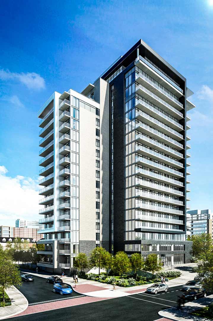
| The Bowery, promotional image via Richcraft |
The Bowery (from Frisian/Dutch bouwerij = a building) by Richcraft — "NYC come to Ottawa" — sits at 255 Bay Street, facing west. Its somewhat T-shaped footprint straddles the block between Gloucester and Nepean Streets. I first noticed the site excavation in the spring of 2015 as I cycled past en route to Tech Wall. Construction was well under way the following year.
Architect's renderings like the one above can be forgiven some license when they portray a building's surroundings. In this case, a bit of adjoining built heritage has been glossed over. Notice the shrubby trees tucked into the indent at the base of the tower. A similar clump is hinted at on the far side of the tower's main entrance. Neither planting exists, but something older has been preserved in their stead.
Here's a photo of the southeast corner of Bay and Gloucester, followed by the northeast corner of Bay and Nepean.
 |
| Bayscorner Grocery, 245 Bay St. |
 |
| Ricardo's Pizza, 267 Bay St. |
Cosmetic details aside, they're like peas at either end of the same pod. Were these two stores built at the same time? Were they the first permanent structures on this piece of land? And were they both purpose-built as "corner" stores?* Let's see what the records have to say.
* * *
The earliest Goad Maps at my disposal appear to date from 1878 — or at least a sheaf of undated individual sheets have been tipped into a folder labeled "1878". The block bounded by Bay, Gloucester, Nepean and Lyon (then "Sally"**) is found on sheet #42. As of the assumed date, Goad shows the block halfway built-up with simple houses, a mix of singles, doubles and rows, some of wood, some of brick, and a few brick-on-woods. One-and-a-half and two-storey construction is the norm. A few houses have simple front verandahs, most have summer kitchens out back, and beyond that, a tangle of wooden stables and sheds. I see none of the Victorian turrets, conservatories and cross-gables that would signal wealth or prestige. Those houses were built further north and closer to the cliffs. If you view this image at full size, you can just make out the widths of the pine sidewalks, five and eight feet.
 | |
| The block under discussion is #264, directly above the word "Bay |
Neither store has been built yet. Nor indeed have many of the houses. Notice the square wooden shed at the corner of Gloucester and Bay — the eventual home of Bayscorner. The numerous, small orange/yellow houses on this plan were also made of wood, while brickwork is shown in red. Notice St. Patrick's Irish Catholic Church (extant, completed 1875), built of stone in block #255 facing onto Kent. The associated orphanage (block #254) was also built by 1878, as was the Catholic school (evidently rebuilt, currently St. Patrick's adult school, ESL and computer). The orphanage grounds are now the site of Centennial Towers at 200 Kent, a 15-storey glass box with a cruciform footprint, built in 1965 — I'm sure it was the cat's meow at the time.
My next set of records date to 1912. Here's Goad again, this time with a closeup of block #264.

Infill is denser and sheds, if anything, more rife. The Bay/Nepean shed has been replaces by a small one, set back from the roads. Houses have been built on Bay, constructed of wood with brick veneer. The present building at the corner of Bay and Nepean shows up here, making it over 100 years old. I have to believe that its twin across the block showed up shortly thereafter. The building at Nepean displays a signature angled doorway, suggesting to me that it was purpose build as a storefront — a drugstore in this case. The street numbering suggests an apartment above the store and a second address (2 storey) in the rear (?), facing on Bay.
The Might Ottawa city directory for the same year lists this strip of Bay Street thus...

So, we know that Clarence H. Lewis was our druggist and that #s 249, 251 and 259 were occupied. Directly across Nepean a Mrs. Rose Ventura sold fruit, while across Gloucester, a nameless Chinese person or persons plied the laundry trade. It's noteworthy that Mrs. Ventura (likely a widow) warranted a listing by name despite her gender and probable Mediterranian heritage while the "Chinese" was reduced to an adjective and a function.
Might 1914 lists druggist Lewis as having moved to 245-'47 Bay so yes, the Bayscorner building was built within two years of its Nepean Street twin. The nameless Chinese were still washing clothes on the north side of Gloucester and Mrs. Ventura still sold fruit south of Nepean. The following year another Chinese laundry had taken over the original drugstore location at 267 Bay — the older laundry at 239 was apparently still in business.
FF to the present, Bayscorner could making a killing on those Bowery residents if they play their cards right. As for Ricardo's pizza, I don't know how long they've been in business, but sitting right next to a new condo tower can't be all bad, can it? And what's not to love about their green pepper, mushroom and onion mascot?

*Almost, yes-ish, and probably.
**Possibly Sarah "Sally" Olmstead, wife of Nicholas Sparks, widow of Philemon Wright Jr.