Wednesday, 27 December 2017

480 Somerset West


I know, I know — it looks lopsided as hell. That's what I get for trying to center a symmetric building that has an asymmetric element tacked on to one side, as they both sit on a gentle slope rising toward Nanny Goat Hill. Live and learn...

There are still a few of the original brick houses on this stretch of Somerset, so this building sticks out nicely. Institutional from the get-go, #480 demonstrates how a coat of paint and some colour-coordinated trim can make a cinder-block box look like a converted Kingdom Hall. Sadly (or not) the low-relief door and window treatments recede under that wash of ecru.

So, if not a house, what then? An office now, obviously — that Co-operators sign looks like it came with the place though we know it didn't. Surrounded by narrow, single-family houses, 480's flat roof and basement-stairway enclosure show up clearly on geoOttawa's 1958 aerial photo. The width of the lot makes me wonder if 480 replaced two old houses, but Goad 1912 (sheet 55 block 373) shows a "contractor's yard" with wooden sheds and empty space between houses 474 and 490.

Ottawa's Golden Age of Cinder-Block was a post-WWII phenomenon, so that gives us a 13 year window of likely construction, from war's end in '45 to the aerial photo-op of '58 — Can we hone that date? Time to hit the newspapers...

...and we hit pay dirt with an Ottawa Journal article from the summer of 1948.


Later mentions cite the "No. 2 Health Centre" as one of four built around the same time, in response to the post-war baby boom.

A January 1954 Journal spread (and a great excuse for half a page spread of cute baby photos) describes an afternoon's DPT vaccination clinic at #480 while a piece from '58 mentions a "Salk vaccine" (polio jab) clinic. When it opened, #2 Health Centre was in the vanguard of community walk-ins designed to ease the burden on emergency rooms — by the 1970s it was focused (with a certain irony) on family planning, viz a bizarre October 6 1971 article opening with this jaw-dropper, emphasis mine...
"Parents protesting a lack of day-care facilities in Centre Town Tuesday were told "this is a family planning clinic — if you'd come here before, you wouldn't have this problem."[ouch!]
The problem was 11 infants and children and their parents who camped in the basement of the Ottawa-Carleton Regional Health Unit office at 480 Somerset Street West Tuesday for 10 hours.
The protesters, members of the year-old Bronson area day-care co-operative said that they would remain in the basement until either their demands [adequate daycare in a permanent location] were met or they were removed bodily..." — Sandra Woods, Ottawa Journal
And that, ladies and gentlemen, is where our heads were at in the '70s. The Journal indicates that #480 continued as a clinic until at least 1979 (the daily ceased publication in 1980), after which date I sort of loose interest — although the row houses to the west are worth looking at. I remember Octopus Books and later(?) Thuna health food store, which moved and morphed into Herb & Spice. I retain a mental picture of a young Jeff Sugarman standing shirtless in the doorway, telling two (female) Jehovah's Witnesses (regarding religion) that "my body is my temple". Okay, you had to be there ;-)

Tuesday, 26 December 2017

424 Lisgar Street


424 Lisgar sits on the south side of the street, a block and a half west of Bank. I'm not a fan of painted brick but sometimes it makes you stop and look, and take a picture as I did, heading home from Massine's YIG. The pair of trees (maples? should have looked at the leaves) largely hide this building in summer — here, their bare branches emphasize its bilateral symmetry.

The foundation — real masonry by the looks of it — tends to put construction before 1910 while the mass, symmetry and lack of fussy brickwork look post-1900. We have evidence that the mansarded third floor is an add-on, and surely the cinder-block porch and iron balconies replace wooden originals.

#424 seems to have been a walk-up apartment for much of its life, though how it got its start is a bit murky. My copy of Goad 1888 (sheet 55, block 300) bears a glued-on bit from 1891 showing a squarish foundation (reassuringly labled "foundation") with a smaller, squarish rear extension. The lot bears the alternate address of #78, since abandoned, indicating a previous numbering scheme that may have commenced at Bank Street rather than by the Rideau Canal as it does today.

Goad 1888 amended '91, note #78 between 418 and 434

The Might Directory for 1901 lists an unfinished building next to a vacant lot. Neither are numbered, either would date completion to after Victoria's death in January of that year, though as we have seen, someone had ideas about at least ten years previous.

Might 1909 lists four tenants. Three years later, Goad 1912 depicts the two-storey, brick-on-wood "Lisgar Apartments" with a flat roof and rear light-well, in keeping with a four unit building, though without the rear extension shown in the 1891 drawing. And yet, that same year Might lists only one occupant, a Miss Ruby E. Legendre. This makes my head hurt.

#78 renumbered, the two-storey "Lisgar Apartments" — note the light-well

Ruby is still alone the next year. Then, from 1914 to 1916 Might lists the six unit "Camille Apartments" with Mrs. Letitia Legendre (Ruby's widowed mom most likely) living in unit 1. Does this mean that the third floor was added between 1912 and 1914 or was the Camille stowing two extra tenants in the basement? I have no idea.

Nor did I find much about the Legendres, apart from the fact that Ruby and her sister Jessie were active in the YWCA circa 1900 and participated in that organization's "Band of Hope". Ruby sang and Jessie played piano and organ. Musical training suggests there was some money in the family, though I can't identify the father with any certainty. I do have reason to believe (public school mentions) that Ruby was in her early 20s by the time she lived at #424 in 1912 and '13. My tentative theory is that Mr. Legendre had planned a family home at the address. Construction was halted by his death until Mrs. Legendre, with the help of her young adult daughters, reconfigured the plan as an income property. But of course, this is guesswork.

The six-unit Camille appears in Might at least as late as 1928 — I have no records for 1929 to 1940. During WWII and for some years after, rooms were often rented out within apartments as was common practice. I'm guessing that the porch/balcony treatment dates to the 1950s.

One oddity — I haven't been behind the building in person, but Google seems not to show the rear light-well indentation from Goad 1912. If it were me, I would have filled it in when I added the third floor.

Friday, 22 December 2017

388 Albert Street


The Albert/Lyon/Slater/Bay block (#261 per Goad, sheet 44) was roughly half built-upon by 1878 — with small-to-medium houses, most of wood, a few brick-on-wood. The original #388 was a wooden one-and-a-half, almost certainly front-gabled. It had a rear summer kitchen with rear sheds attached. Ten years later Goad would depict the same house as a two-storey, with sheds reaching back to the rear property line.

By 1912, Goad shows the house in its present configuration — a two-and-a-half-storey gambrel with a two-storey front bay window and two-storey flat-roofed rear extension, all brick-veneered. The boxy front room is a later, cringe-worthy add-on. It's likely that the present house incorporates the original 19th Century structure.

The A.S. Woodburn Directory for 1875 (pg. 19) notes "Sparks George, laborer" at this address — was he related to Nicholas? By 1884, Woodburn lists "Sparks Abraham, of Sparks & Edey, carpenters and builders". They sound like they could do renos.

The 1875 date gives the house (in whatever form) an occupancy history of at least 143 years. It's now one of only three buildings (all domestic) left on an otherwise empty block. Like they say, "Watch this space" — it just might do tricks.

See Good Eats here.

Tuesday, 19 December 2017

Oh Hey, it's Another Map

With my left foot on the mend I've finally been able to scope out the neighbourhood in person. And with a fresh Borg implant in my right eye I can actually make out the contour lines on geoOttawa's interactive map of the city — hence the following...


This map covers much of same area as Goad's did in the previous post. The brown contour lines are calibrated in metres above sea level (ASL) — all contours, including the light brown "minor" lines, are two metres apart. As always, click on the image to view large.

You can see two yellow patches on the map. They don't exactly match the yellow areas on Goad's map but they are related. The lower patch is that part of Nanny Goat Hill which rises beyond 80 metres ASL.  The upper patch is Parliament Hill, where the elevation reaches the 80 metre mark just north of Wellington Street — think of the embankments directly behind the stone and iron fence. Three minor contours looping across the Parliamentary front lawn confirm that the Centre Block is built on an 86 metre ASL plateau. No other ground on this map reaches, let alone exceeds an 80 metre elevation.*

The red triangle demarks this walker's subjective impression of all that is NGH, its shape roughly echoing the "yellow tongue" we saw in the last post. The lower right corner of this triangle sits  at the northwest corner of Dundonald Park, where a gentle rise that began near Bank Street flattens off noticeably. The top corner, as we've already seen, sits at the junction of Bronson and Laurier Avenues. On the west... well, that cliff is hard to ignore. And as to the bottom left corner, things do start to drop away somewhat around Empress and Arthur — by the time you reach Somerset and Booth, it's all downhill with a vengeance.

Oh, and I think I figured out where that "Nanny Goat Hill" restaurant whatever thing used to be, back in the '70s — it looked bigger back then.


*For a list of significant Ottawa elevations, check out Wikipedia here.

Tuesday, 12 December 2017

Before the Bowery

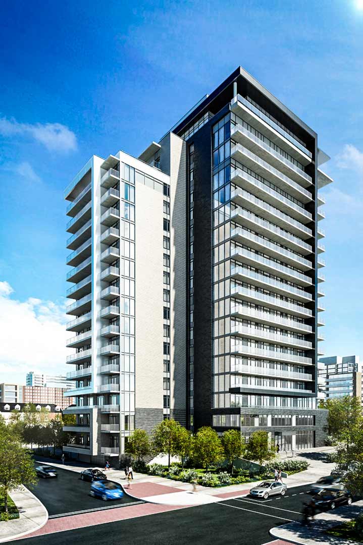
The Bowery, promotional image via Richcraft
Less than a week after I moved into my new apartment, a flyer landed in my mailbox suggesting that I move again, into a newer, larger and more prestigious building. Prestigious, edgy, hip, whatever — what is one to make of a condo tower named after one of New York City's most notorious skid rows, lately gentrified? I checked out the flyer (which included the above rendering), noted the floor-to-ceiling windows (I'll bet the view is awesome) and realised that I could move in immediately if I withheld condo fees and stopped eating.

The Bowery (from Frisian/Dutch bouwerij = a building) by Richcraft — "NYC come to Ottawa" — sits at 255 Bay Street, facing west. Its somewhat T-shaped footprint straddles the block between Gloucester and Nepean Streets. I first noticed the site excavation in the spring of 2015 as I cycled past en route to Tech Wall. Construction was well under way the following year.

Architect's renderings like the one above can be forgiven some license when they portray a building's surroundings. In this case, a bit of adjoining built heritage has been glossed over. Notice the shrubby trees tucked into the indent at the base of the tower. A similar clump is hinted at on the far side of the tower's main entrance. Neither planting exists, but something older has been preserved in their stead.

Here's a photo of the southeast corner of Bay and Gloucester, followed by the northeast corner of Bay and Nepean.

Bayscorner Grocery, 245 Bay St.
Ricardo's Pizza, 267 Bay St.

Cosmetic details aside, they're like peas at either end of the same pod. Were these two stores built at the same time? Were they the first permanent structures on this piece of land? And were they both purpose-built as "corner" stores?* Let's see what the records have to say.

*     *     *

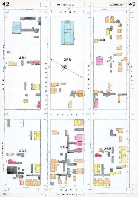
The earliest Goad Maps at my disposal appear to date from 1878 — or at least a sheaf of undated individual sheets have been tipped into a folder labeled "1878". The block bounded by Bay, Gloucester, Nepean and Lyon (then "Sally"**) is found on sheet #42. As of the assumed date, Goad shows the block halfway built-up with simple houses, a mix of singles, doubles and rows, some of wood, some of brick, and a few brick-on-woods. One-and-a-half and two-storey construction is the norm. A few houses have simple front verandahs, most have summer kitchens out back, and beyond that, a tangle of wooden stables and sheds. I see none of the Victorian turrets, conservatories and cross-gables that would signal wealth or prestige. Those houses were built further north and closer to the cliffs. If you view this image at full size, you can just make out the widths of the pine sidewalks, five and eight feet.

The block under discussion is #264, directly above the word "Bay

Neither store has been built yet. Nor indeed have many of the houses. Notice the square wooden shed at the corner of Gloucester and Bay — the eventual home of Bayscorner. The numerous, small orange/yellow houses on this plan were also made of wood, while brickwork is shown in red. Notice St. Patrick's Irish Catholic Church (extant, completed 1875), built of stone in block #255 facing onto Kent. The associated orphanage (block #254) was also built by 1878, as was the Catholic school (evidently rebuilt, currently St. Patrick's adult school, ESL and computer). The orphanage grounds are now the site of Centennial Towers at 200 Kent, a 15-storey glass box with a cruciform footprint, built in 1965 — I'm sure it was the cat's meow at the time.

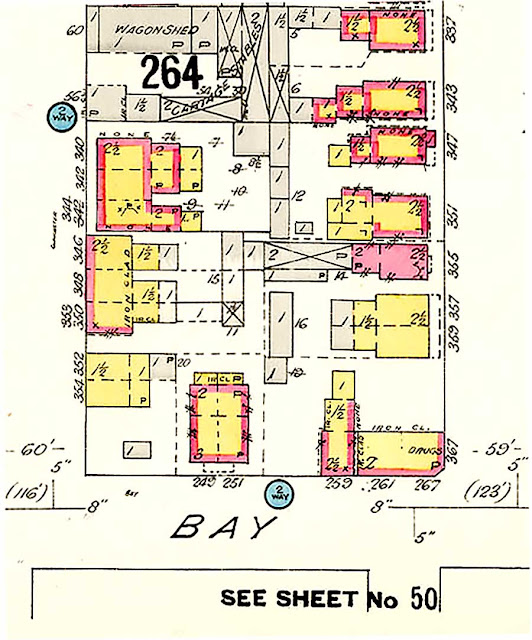
My next set of records date to 1912. Here's Goad again, this time with a closeup of block #264.


Infill is denser and sheds, if anything, more rife. The Bay/Nepean shed has been replaces by a small one, set back from the roads. Houses have been built on Bay, constructed of wood with brick veneer. The present building at the corner of Bay and Nepean shows up here, making it over 100 years old. I have to believe that its twin across the block showed up shortly thereafter. The building at Nepean displays a signature angled doorway, suggesting to me that it was purpose build as a storefront — a drugstore in this case. The street numbering suggests an apartment above the store and a second address (2 storey) in the rear (?), facing on Bay.

The Might Ottawa city directory for the same year lists this strip of Bay Street thus...


So, we know that Clarence H. Lewis was our druggist and that #s 249, 251 and 259 were occupied. Directly across Nepean a Mrs. Rose Ventura sold fruit, while across Gloucester, a nameless Chinese person or persons plied the laundry trade. It's noteworthy that Mrs. Ventura (likely a widow) warranted a listing by name despite her gender and probable Mediterranian heritage while the "Chinese" was reduced to an adjective and a function.

Might 1914 lists druggist Lewis as having moved to 245-'47 Bay so yes, the Bayscorner building was built within two years of its Nepean Street twin. The nameless Chinese were still washing clothes on the north side of Gloucester and Mrs. Ventura still sold fruit south of Nepean. The following year another Chinese laundry had taken over the original drugstore location at 267 Bay — the older laundry at 239 was apparently still in business.

FF to the present, Bayscorner could making a killing on those Bowery residents if they play their cards right. As for Ricardo's pizza, I don't know how long they've been in business, but sitting right next to a new condo tower can't be all bad, can it? And what's not to love about their green pepper, mushroom and onion mascot?


*Almost, yes-ish, and probably.
**Possibly Sarah "Sally" Olmstead, wife of Nicholas Sparks, widow of Philemon Wright Jr.