Wednesday 31 January 2018

the Lyon Street Mini-Church


Let's assume that this little oddity wasn't always an esthetician's studio. Indeed, the present occupant of 250a Lyon somewhat confirms this — Meta Esthétique's website tells us they have been in business (here?) since 1979. The building looks older than that and was, I'm daring to guess, purpose-built as church — but when, and by whom?

As to the when, we know better than to guess. Church architecture is so fraught with stylistic revival that some of Ottawa's oldest-looking churches are as young as I am. 250a's bizarre scale and concrete construction (trust me, those aren't stone blocks) are quirks that could have been deployed at any time in the last century — or this one for that matter. Let's start our hunt for beginnings with the lot itself. Here's an image adapted from Goad...

after Goad, sheet 42, 1912 reprint

"265" is the reference number for the block — we're looking looking at the eastern end thereof. I've added street names and indicated the eventual position of the church at 250a Lyon. We can see how that position was previously filled by three single-storey wooden storerooms (shown in yellow) leading off the back-ends of a row of conjoined brick houses (in red). The houses still stand but their wooden nether bits were soon to be knocked down. Notice that for whatever reason, the house furthest to the right was numbered 250 Lyon despite facing onto Nepean.

The Might Directory's Lyon Street listings for 1913 say nothing about 250a, jumping obliviously (and forgivably) from 250 to 252. Such is also the case for 1914, 1915 and 1916. This, I fear, is one of those instances of Might dropping the ball for at least two years in a row, as a newspaper search will demonstrate.

Scrolling through the Ottawa Journal archives reveals the little church's colourful history, taking us back to the spring of 1914. From an article dated Monday, April 13 of that year...
Lutheran Church is Dedicated on Easter Sunday
Special Services Held at St. Peter's on Lyon Street
Easter services at St. Peter's Evangelical Lutheran church, Lyon Street, will long be remembered by the members, adherents and visitors who attended yesterday. Banked high with flowers, the pretty little church, which has been recently erected as a place of worship, was a fitting commemoration of the resurrection of Our Lord. Easter had also been chosen for the dedication of the new church and all services were attended by congregations that filled the building. [...]
The article describes the origins of the institution in 1910, telling of a first meeting at the King's Daughters Guild Hall (119 O'Connor, a house since demolished), then of its formal organization as St. Peter's in October of the same year, and of a subsequent move to 292 Lisgar Street (another house since demolished). The article continues (and here's where our mini-church enters the picture)...
On December 25 [1910] it was decided unanimously to extend a call to Reverend J.J. Clemens, of Guelph, which call was accepted and Mr. Clemens was installed as permanent pastor on May 14, 1911. The property on Lisgar street was sold shortly after the coming of the pastor and property purchased at the corner of Lyon and Nepean streets where the new church has been erected.
There are besides the church building also three back dwelling houses upon this property. One of these furnishes a home for the pastor, the revenue from the other two houses is used to pay taxes and interest on the loans upon the property. [emphasis mine...]
We have already seen these three houses on the Goad map above, and we remind ourselves that  Might ignored the church from 1914 through 1916 inclusive (despite Easter Services having been held there in the spring of '14. Nevertheless, Might does list the Reverend Clemens as living in #250, the pastor's house on the very corner of Lyon and Nepean*, as early as 1914. I can only guess that Might (or his clerks) saw the occupancies on Lyon being numbered from 250 to 252 and, for two years running ('15 and '16) failed to realize that an address had been inserted between them.

Thus we have a "pretty little church", St. Peter's Lutheran, shoehorned into a narrow back-lot at 250a Lyon no later than the spring of 1914. In that same year we know that the church's pastor, the Reverend J.J. Clemens, lived next door at #250. Assuming that early references describe the same church standing today, 250a Lyon will be at least 104 years old this spring.

*     *     *


This is an ad of the sort run by the Church through the 1940s and into the '50s. The address is typically given as "at" or "near" the corner of Lyon and Nepean — no street number is cited. Here's part of an Ottawa Journal article from December 3, 1966...

"Faces of Ottawa — Rev. Arthur Conrad"
Much of the article is, of course, devoted to the Reverend Conrad himself, but author Ketchum does mention the year of the move from Lyon...
[...Conrad] recalls with pride and gratitude the dedication of the church and parish hall in 1954. The then governor general, Vincent Massey, and two Maritimers from Lunenberg took part in the service. [Conrad was born in Bridgewater, NS.] They were Senator John J. Kinley who had generously donated the choir pews and Robert Winters, at that time minister of public works.
It was a happy day for the pastor and congregation in 1964 when the entire first mortgage was liquidated and burned at a special service, ten years before maturity. [emphasis mine...]
The present St. Peter's is an Ottawa landmark. It appears in this stained-glass "teaching window", perched on its limestone bluff overlooking Lebreton Flats. The image refers to Matthew 16:18 — "And I tell you that you are Peter, and on this rock I will build my church, and the gates of Hades will not overcome it."


Jesus' double-entendre lay, of course, in the fact that the name Peter means "rock".

*     *     *

St. Peter's move to Cathedral Hill leaves us with roughly twenty-five years of 250a Lyon's history unaccounted for — from 1954 until Meta Esthétique's purported arrival in 1979. Fortunately, we can rely on The Journal for coverage until 1980. I've tried to interpolate a handful of mentions with information from the City Directories held at the Ottawa Public Library.

From the mid-fifties to the early seventies (per the Directories), 250a was home to an organization variously known as the "Immanuel Assembly Services Church", "Immanuel Ecclesia Undenominational Church", and the "Evangelistic Centre".

During this time, the Lyon Street address stayed largely out of the news. An exception dates from September 1959 — (next to a photo of Bing Crosby and his new baby girl) "Founder of Sect to visit Ottawa on Weekend — Rev. A.U. Michelson, founder and minister of the First Hebrew Christian Church of Los Angeles will preach on Sunday in Ottawa [ ...] He will speak in the Capitol Theatre at 2:30 p.m. on 'Crisis in Palestine in the Light of Prophecy: Will Russia Invade Palestine?' Sunday morning he will preach at the 11 o'clock service in Emmanuel[sic] Ecclesia Church at 250A Lyon street."

Again during this tenure, a spate of ads, perhaps disturbing by today's standards, appeared in December of 1969.

I'm sorry but I can't read that without picturing little children gulping down "spiced" cocoa and playing in basement sandboxes full of sand-trout — or was that the Golden Path? Either way, it sounds hinky to me.

By the mid-seventies, as befitted the times, 250a Lyon was hosting a less conventional brand of devotion. In 1974 it was home to the "Science Center" (rummage and bake sale), then the "Psi Center" (anyone for Zener poker?)and, by 1975,  the Institute of Applied Metaphysics ("I AM") which seems to have adopted the stripped-down, quasi-scientific aesthetic of the various self-realization/assertiveness cults emerging at the time (Scientology, The Process, EST).

Ottawa Journal, 1975 — that logo is so BoC
I AM's brief but colourful stay seems to have lasted until the summer of 1976. In March of that year, The Journal reported on an odd event.
All-Night Rock for Body and Soul
Back and forth, back and forth they went, 25 rockers, tired and weary from their all-night sprint but determined to finish the 24-hour rocking chair marathon sponsored by the Institute of Applied Metaphysics.The rockers were taking part in a national marathon to help raise money for their three residential schools in Canada [again, ???!!!...]
The institute is a federally-chartered organization founded in 1963, which offers courses in the development of creative resources to harmonize the mind and body. In Ottawa there are more than 200 active members [...]
The last I AM / Lyon Street mention I can find shows the Institute with cosmic egg on its face. Again from The Journal, Monday, June 14 1976.
A World Without End
The world did not end at 9 p.m. Sunday, as predicted by the Institute of Applied Metaphysics, usually reliable sources have informed The Journal. These sources added it was business as usual on this planet after the zero hour passed uneventfully.
No extra-terrestrial being had landed to tell earthlings how to live in peace and harmony, as forecast by an institute member. [...]

Nobody answered either the bell or the phone at the institute's office (a converted church) at 250-A Lyon Street. Maybe the members who had made the dire prediction at a film showing Thursday night had decided to face the grim happening elsewhere. [...]
The City Directory for 1977-'78 lists #250a as "vacant". By the fall of 1978, the little church had been renovated and (dare I say) "re-framed" as an art gallery. "The Church — An Art Space" was opened — at no small expense I'm sure – by Mitzi Bidner, a Montreal-based artist and consultant. Perhaps Ms. Bidner's tastes were too avant-garde for stodgy little Ottawa — her brief but well-intentioned outing was last-mentioned in September 1979, hence the irony of the following advertisment.
Christensen Real Estate, The Journal, March 15 1980

*     *     *

The address is listed "no return" in the 1980 Directory and not mentioned at all in the '81-'82 volume. 1984 lists "St. John Associates, audio visual communications" and '86 gives us "Shonn's Beauty Shop". This would contradict the idea that Meta Esthétique has been there since 1979. Perhaps I took the wording of their website too literally — maybe they started somewhere else then moved into the church. Did Shonn's become Meta? I'll have to drop in and ask the next time I'm on Lyon.

By the way, I'm assuming that the church presently at 250 Lyon is the same one built in 1914. There'll be egg on my face if it isn't.


*250 Lyon had been, immediately prior, the home of Mrs. Mary Ahearn, apparently the widow of artist Maurice (died April 1910), a relative (possibly brother) to Thomas Ahearn. More research is called for here. I can find no examples of Maurice's work online.

Friday 26 January 2018

Hollywood North


Welcome to Hollywood North, please excuse our snow. The Might Directory didn't list 233 Nepean in 1923 but some dodgy aerial photography seems to have captured it in '28, so let's say mid-twenties, inter bella and all that jazz.*

As walk-ups shrank, they shed their Edwardian encumbrances. Two and three-storey apartment blocks popped up all over Ottawa, often with minimal styling save some combination of glass-block to light the stairwell, and nods to deco/moderne in the form of corner windows and/or decorative brick courses, kept very clean and simple.

The Hollywood took a different tack, name-checking southern California's nexus of glamour, and appending mission-style fixtures (clay[?] tile, a rounded door arch) to what is otherwise a brick shoe-box. Was the stepped parapet meant to be read as an Aztec shout-out? Fusty window lintels are long gone, while the concrete sills echo the building's foundation, faux sandstone rebranded as faux adobe. Even the paving-stone effect surrounding the door frame is, on close inspection, thoroughly modern concrete, molded and dyed.

The Hollywood seems to have been the first house built on this spot, a saucy piece of infill tucked between two 19th century dwellings.

*Caveat to self — I'm finding ever more instances whereby not being listed in the City Directory isn't the same as not existing. The next post will offer an example.

Wednesday 24 January 2018

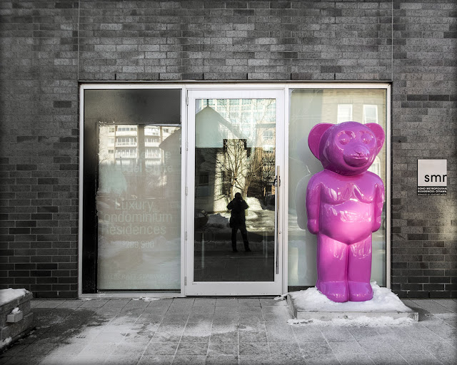
A bare bear...


...seen here freezing its (their?) tits off, standing guard outside the Soho on Lisgar. Apparently one of a set created by Spanish artist Eladio de Mora ("dEmo").

Monday 22 January 2018

245-251 Nepean


This property was depicted as a vacant lot on Goad's 1878 (sheet #38), then shown as an all-wood row ten years later, making these houses at least 130 years old. Two units have been fitted with rear dormer windows and one with a skylight. The original summer kitchens and rear sheds have been variously modified over the years. The siding, I assume, is not original. There seems to be a plaque, must check that out — also give the siding a poke. All in all, the building seems well-maintained, from the outside at least.

It would be a fair guess that these were built as working-class homes. Woodburn doesn't mention them for 1884, narrowing our construction date window to '84-'88.  Polk & Woodburn 1890-'91 does list the houses and gives us a good idea of their original demographic.
245 John Wilson, carpenter
247 John O'Connell, foreman — Church Brothers
249 Elizabeth Killeen, widow of James
251 Archibald McArthur, driver
Mr. O'Connell's employers, Thomas and William Church, operated a planing mill on the southwest corner of Kent and Lisgar (Goad indicates a fire there, with "scattered wood" in October of 1898). I don't know what Mr. McArthur drove but horses were likely involved. It goes without saying that Elizabeth Killeen was a widow, otherwise she would have been known formally as Mrs. James Killeen (and not listed at all).

Regarding these names in general and Killeen in particular — while most of Bytown's first Irish residents lived in Lower Town or, for that matter, on the banks of the Canal they helped build, many were living in this part of Centretown by the latter decades of the 19th Century.  Indeed, I've found evidence of an Irish settlement on Somerset west of Bank at a time when the surrounding land was still deserted. More on that later. Of course, 245-251 Nepean was a stone's throw from what was then the heart of Ottawa's Irish Catholic community, St. Patrick's Church (now Basilica) at Nepean and Kent — completed in 1875.

*     *     *

Later—
I was able to check out that plaque this AM, the one next to the door of #247. It reads...

c. 1889 Quinn's Row
A classic and simple design in clapboard.
This row was built for Patrick Quinn,
and is the only surviving 19th Century
working class terrace in Centretown.
Designated Heritage Property

Well there you go — I thought it looked oldish. "Circa 1889" does narrow things down a fair bit, though it makes us wonder why Goad portrayed the row as a fait accompli in January of the previous year. It wouldn't be the first time I've seen a heritage plaque slightly at odds with a Goad map.

Patrick Quinn was likely the contractor of that name, listed by Woodburn (1884) as living at 352 Nepean (since demolished). Sadly, the only news mentions I can find for Mr. Quinn involve run-ins with the law — assault (on a woman) and aggressive attempts to "borrow" money from various residents of Metcalfe Street.

Quinn's Row is mentioned in a Heritage Ottawa newsletter from 1986 (pdf).

Oh, and the siding? Definitely vinyl — it wiggles.

92 Empress


A small house on a tiny lot uses heavy, bracketed cornices and confident window treatments to make a big statement. Its appearance on the Goad maps indicates construction some time between 1888 and 1912, while the Might Directory lists occupancy in 1909 (Charles T. Lawson, v.p. Thos Lawson & Sons Ltd, casting and molding). #92 may have been built in tandem with the larger double block next door — note the identical lintel-over-basement-window masonry.

140 Bronson Avenue


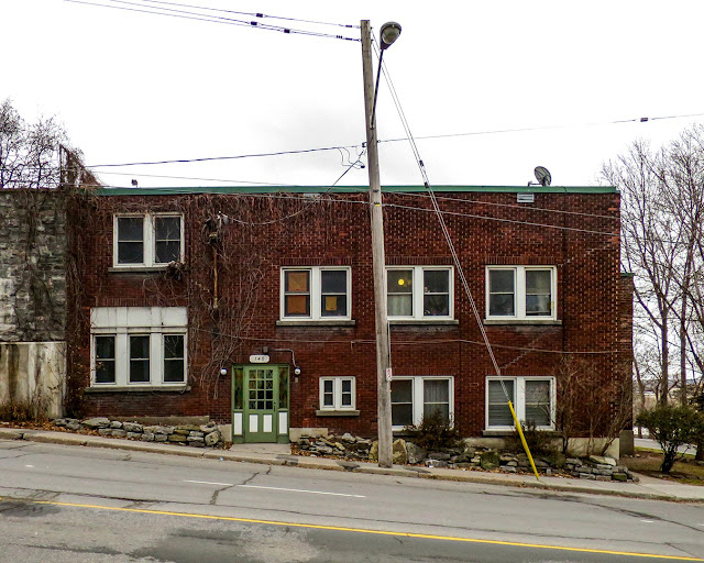
This 140 Bronson sits on a triangular patch of ground at the southwest corner of Slater Street, wedged into the base of the Nanny Goat cliff. You can see how it abuts the back-yard retaining wall of the of the old Alexander Fleck mansion just uphill at 593 Laurier West.

The steep grade of Bronson Avenue as it runs down to Slater required that #140's concrete foundation be poured in stepped levels — I count three across this facade. I wonder how well that base is grounded to the bedrock below, given that the north (to your right) side of the building slumps a tad, as evinced by some cracking brickwork and the slightly misaligned window frames. There has to be some scree and back-fill under there. This part of the Nanny Goat limestone grades into patches of glacial till, so at least Leda clay isn't an issue.


This vertiginous Google shot shows the relative positions of the Fleck house (left of center, signature cupola, busy roof-lines) and #140 (right of center, mostly flat roofs, improvised massing). Note the long peak-roofed section toward the back of the building. Aerial photos at geoOttawa give 140 Bronson a construction date some time after 1928. The escarpment continues on the east side of Bronson to become the Tech Wall graffiti wall.

Catherine Boucher (@bearswim on Twitter) adds  "...And providing some affordable housing. Leased from the City by @CCOChousing after Mike Harris killed the social housing programs. Built to be a furniture warehouse during WWII. Turned into (furnished) apts after the war."

Sunday 21 January 2018

Firestarter

Firecrackers were imported from Macau, Hong Kong and Guangdong (Canton) China — (image source).
Are you old enough to remember when Victoria Day was called "Firecracker Day"? If so, you probably remember firecrackers themselves. I don't know whose brilliant idea it was to arm children with incendiary devices, letting them run wild in the streets to blow things (and each other) up.  Remarkably, this was the norm until 1972 when Canada outlawed this kiddie-dynamite. I've found a news story from 1964 set during the lead-up to that year's shenanigans. It describes an event of the sort that would provoke the eventual ban.

From the Wednesday, May 6 1964 edition of the Ottawa Journal...
41 Homeless: Probe Nanny Goat Hill Fire, Suspect Children Started It

City fire investigators suspect children may have started the raging fire which swept through seven homes at the base of Nanny Goat Hill during the supper hour Tuesday. Forty-one persons, including 18 children, were left homeless after fire destroyed four houses and gutted another three on Lorne and Primrose Avenues.

Four houses on Lorne Avenue, numbers 50, 54, 56 and 58 were destroyed. Numbers 54 and 56 were two-storey brick homes, number 50 was stucco and 58 was a wooden frame house. The top storey at 109 Primrose Avenue, a two-storey brick[*] dwelling was gutted and the back rooms of a wooden frame tenement at 111 and 113 Primrose were gutted [...]

The homes border on land marked for NCC expropriation in LeBreton Flats. However, the exact area is one considered some time ago by the city for urban redevelopment. Exactly where and exactly how the fire started has not been determined, but fire officials and police say they have reason to believe that children playing with firecrackers may have caused the fire [...]

More than 50 firefighters from five stations under Deputy Fire Chief Alex McFadden battled the wildly spreading blaze for two hours. Mrs. Arthur Latimer, of 113 Primrose, said she phoned the alarm shortly after 5 p.m. when a young boy came running to tell her there was a fire in her garage [...]


This photo shows 109 Primrose, the house described by the Journal has having its top storey "gutted". The ornate brickwork parapet seems to have escaped damage — or does it post-date the fire? Goad maps and aerial photos suggest that the side yard was never built on. House and yard sit inside the elbow of lower Lorne and lower Primrose. I took the photo from the stairway leading down from the intersection of their upper counterparts. (Lower Primrose west of Booth was originally called "Maple", in keeping with the adjacent tree-themed street names — Spruce, Elm, Cedar etc.) Might (1901) lists Benjamin Guilmont, a watchman for the Victoria Foundry (Bridge St., Lebreton Flats), living at 109 Primrose.

Before the stairway was built, upper and lower Lorne were connected by a steep, narrow roadway running north down the cliff. In 1939, the Belgian-born Ottawa painter Henri Masson depicted this intersection in oils. We can see the road between the Lornes, a dirt ramp held in place by massive stone blocks, a stepped wooden sidewalk hugging the retaining wall opposite. A sign on a utility pole warns us of the steep grade ahead. Originally (Goad 1912), both lower Lorne and lower Primrose dead-ended against the base of the cliff — the empty side-yard likely served as a convenient shortcut between the two.

image via Urbsite, see detailed article here
The rear east side of 109 Primrose is visible on the left of the painting. The chimney has since been repositioned. If the house in the middle looks yellowish, that's because it's made of wood. 58 Lorne was destroyed in the 1964 fire and eventually replaced by a brick building of like height.

*     *     *

This corner of the Flats just below Nanny Goat Hill is part of an older fire-related story. Shortly
after the Great Ottawa-Hull Fire of April 1900, the Charles Goad Company produced a map showing the extent of the conflagration. I reproduce a section of it here...


We can see how the fire, which began in Hull, was driven southward by the wind, through the lumberyards of the Chaudiere island group, across Lebreton Flats and through then-Rochesterville and Bayswater, where it stayed west of Division, now Booth Street. But look at where the flames crossed lower Victoria/Empress, licking the base of Nanny Goat cliff before skirting the stone face toward the west and the south. On its way, the fire engulfed block 323, shown as having all-wood construction and including our lower Lorne and Primrose intersection. Without Nanny Goat Hill blocking the fire, it could have torn into the very heart of Centretown.

*Goad (1912) shows 109 Primrose as brick veneer (on three sides only). "Brick" in the Journal article would describe the external appearance of the house — I'm betting, for example, that 50 Lorne wasn't actually made of stucco. Assuming that #109 was built immediately after the "Great" fire, it's good to see it such good shape after that of '64.

Sunday 14 January 2018

Queen of the Cliff....

...Empress of the Escarpment
A "steep hill partly wooded" aptly describes this stretch of the Nanny Goat Hill cliff, seen here cutting diagonally across the southeast corner of Goad's sheet 49, dated January 1901. The date bears a coincidental significance — it was on January 22 of that very year that Queen Victoria died at the age of 81, ending a reign of 63 years and 7 months. Here, we are shown Victoria (the avenue) leaping from the cliff to a landing on the southern edge of Lebreton Flats, a respectable drop of some 14 metres or 46 feet.*

Victoria Avenue would be renamed "Empress" later in the same decade. I don't have the exact date for the change but a newspaper mention (property sale, "unobstructable view") puts it no later than 1907. Given that Victoria adopted the title "Empress of India" in the spring of 1876, a 20th Century act of recognition seems oddly belated. I can only guess that "Empress" was chosen to dispel confusion between the avenue and downtown's Queen Street, Queen Victoria Street (now simply "Victoria", in New Edinburgh) and the oft-misspelled and mispronounced Vittoria Street just west of Parliament Hill.

Goad's innocent-looking two-word notation in the lower right corner of our image raises interesting questions about this part of our city. "Burnt District" refers to the great Ottawa-Hull Fire of April 1900, less than a year before this map was prepared. What (if any) role did the cliff serve as a firebreak? What houses were destroyed and how were they rebuilt?

An iconic piece of brickwork dominates the right-hand side of this map. The signature angled wings of the "House of Mercy" Maternity Hospital still stand, now the oldest part of the St. Vincent hospital complex. Most of the smaller houses shown here have since been demolished, though a pair of buildings flanking the north side of Primrose at Empress remain.

85 Primrose Avenue

Coloured blue (for stone) on the map, 85 Primrose is labeled "convent". Its rank and file windows befit the conformity and anonymity of its one-time residents. The building is now Annex E of the Bruyère Research Institute. Oddly, I can find no discussions of heritage status for this building.

69 Primrose Avenue

Goad portrays 69 Primrose as a solid-brick "two-and-a-half", which largely agrees with what we see today, allowing for a few renovations. In 1901 this was the home of one Richard Lester "bidr", by which I think the Might Directory meant "bldr". The address is now associated with the Champlain Hospice Palliative Care Program.

Empress Avenue continues north for a short distance past these two buildings, looking very much like a dead end. On close inspection however, this cul de sac marks the top of a staircase wending down the cliff-side to a final block of the avenue, one of "Hidden Ottawa's" delightful features.

Another bit of renaming — "Maria" at the top of the map was the original name for Laurier Avenue West, shown here likewise leaping, as it were, over the cliff. The original footpath down the slope is long-gone. Instead, Slater now hugs the base of the cliff to a point where it joins the western limb of Albert Street. Thus the Empress is reunited with her lamented lost love, Prince Albert.

*Victoria (the Queen) did not leap over a cliff. She met her end with quiet dignity, in bed at Osborne House on the Isle of Wight, attended by her son and successor King Edward VII, her eldest grandson the Emperor Wilhelm II of Germany, and her little dog Turi, the Pomeranian.

 “I am his Highness' Dog at Kew. Pray tell me Sir, whose Dog are you?”


Queen Victoria, 1900

Thursday 4 January 2018

42 Primrose Avenue

on the Southeast corner of Arthur
This little charmer does a good job of hiding behind its trees and shrubbery in summer, which is a shame for us. I believe this is what's called a "four-square" plan. They appeared in the US in the 1890s and were popular through the 1910s and 20s. Many Ottawa examples are smaller than their American counterparts and often dispense with the full-width front verandah typical of the style. Some four-squares (if indeed that is the correct term) in Old Ottawa East/South are positively tiny.

Goad 1912 shows an older house in this spot facing Arthur, scrunched up next to #9 (extant) so this one replaces the original structure. #42 doesn't appear in Might 1923, so it would have been built during or after that year.

38 Primrose Avenue


The Nanny Goat Plateau features houses in a potpourri of styles. Sometimes the same thing can be said for individual houses. I don't know how much, if any of the original structure exists here, but occupancy of the lot dates at least as far back as 1875 (J. Peterkin carpenter, per Woodburn Directory). Goad shows a house of like configuration, brick-on-wood, one-and-a-half storeys in 1888.

The Waterton and Welwyn Apartments

408-414 Albert, at Bay, looking east
I'm grateful to Chris Ryan and his fascination with the history of Ottawa apartment buildings — I doubt I could have otherwise found names for these two. That's the Waterton at 408 on the left and the Welwyn, 414 on the right.

Newspaper mentions of #408 go back at least as far as 1936 — R. J. Bishop of apartment 12 wins $10 in the Journal's "Mickey Mouse Addition Contest" — indicating construction in or before that year. #414 first appears in 1920 (housemaid wanted, apply evenings), then in a 1923 obit (Andrew Ferguson Smith), both suggesting a former single-family house at that latter address. Goad (1912) confirms our suspicion.


Here we see a Victorian-style brick house with a generous side-yard, set on a desirable corner lot. It's surrounded by more cheaply-built singles and rows. Indeed, Goad shows a near-identical configuration at least as far back as 1888. The Woodburn Dirctory for 1884 has no listing for the lot but 1890 gives us "Private grounds" followed immediately by "414 Henderson Alex A physician[,] Garrow Alexander M D". Okay, one family, two doctors, whatever — construction between '84 and '88. For its part, GeoOttawa shows the old house in place until at least as late as 1928.

Given the above dates and their identical designs, the Waterton and Welwyn were likely built at the same time, somewhere between 1928 and 1936, on a space that had been held open by a house and lot atypically large for the block.

The many brick-on-wood houses (yellow bordered with pink) shown on Goad's "block 261" above are testament to Ottawa's rapid growth in the years following 1857, the year that Queen Victoria chose our city as Canada's capital. Often, these cookie-cutter singles and short rows were built simply of wood. Many of the singles still stand, now sheathed in vinyl siding. In some cases, tracts of such housing would be declared slums, notably in the 1960s.

It's thus a paradox to find oft-repeated instances where a large and solidly-built house is torn down to make room for a more modern structure while the humble wooden abodes surrounding it are left standing. Such is the case here. After the block's initial buildup, the large brick house at the corner of Albert and Bay would be bulldozed (or whatever they used) for a pair of trendy inter-WW walk-ups, while aerial photos show that several houses on the east end of the block persisting until the mid-sixties. Only one 19th Century house, 388 Albert, still stands, though I wonder for how much longer.